1640s Map of Brazil - Novus Brasiliae Typus
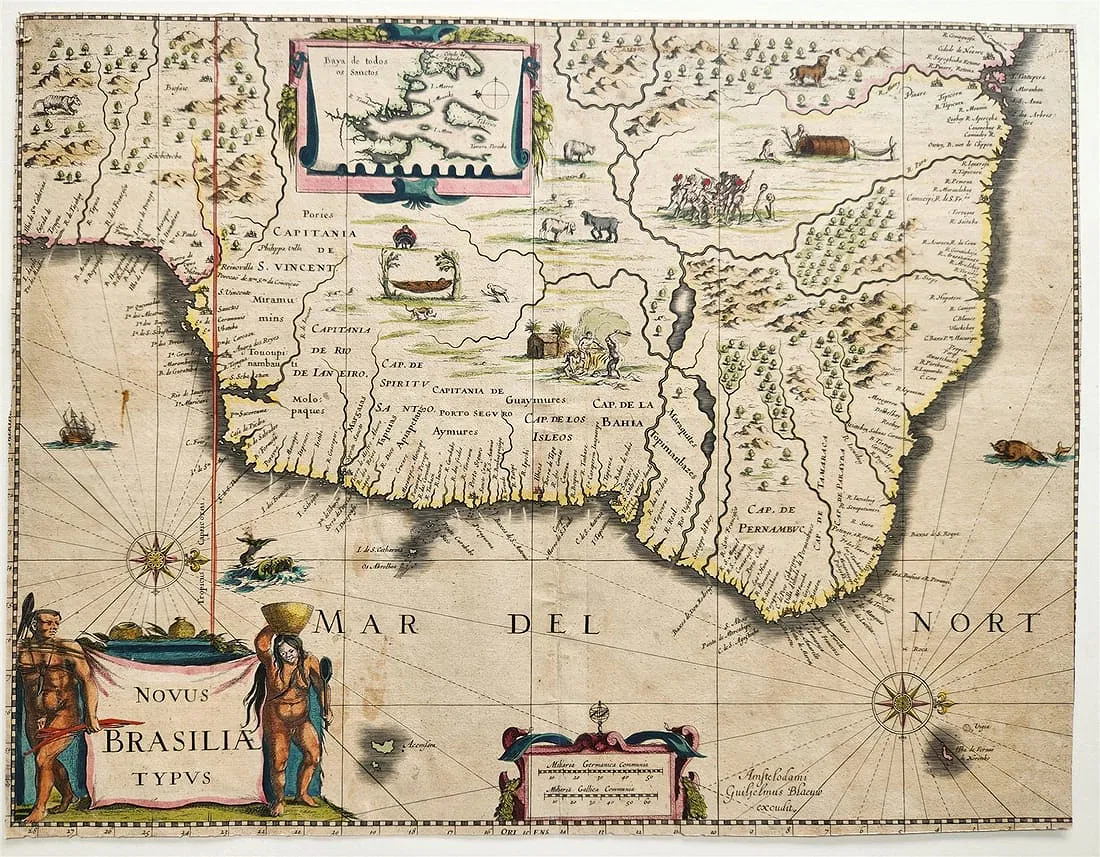
Willem Blaeu's Novus Brasiliae Typus, engraved and hand-coloured in Amsterdam c. 1640, charts the Brazilian coast in precise detail while filling the speculative interior with indigenous scenes, native fauna, and an inset of the Bay of All Saints.
- Date
- c. 1640
- Origin
- Amsterdam: William Blaeu
- Period
- Colonial Period (1500–1822)
- Materials
- Engraving on laid paper, hand-colored
- Dimensions
- 14.5 by 18.5 inches
- Condition
- Good; minor foxing in margins
Provenance
Acquired in Auction 2025
Historical Context
Antique map of Brazil by Willem J. Blaeu. Shows a very detailed and accurate coastline while the interior is still speculative. With an inset maps of Baya de Todos os Sanctos (Bay of All Saints). In the interior depictions of native animals and scenes of indigenous people, including cannibalism. Decorated with two cartouches, two compass roses, a sailing ship and two sea monsters.
From Willem and Joan Blaeu's Atlas Theatrum Orbis Terrarum published in 1640-43. Latin text on verso.
Willem Janszoon Blaeu was born 1571 in Alkmaar. He was trained from 1594 to 1596 by the famous Danish astronomer Tycho Brahe. 1599 he went to Amsterdam and founded a business as globe maker. Later he started producing map and sea charts, including his first world map in 1605. In 1633 he was appointed Hydrographer for the Dutch East India Company (VOC). His most famous work was the Theatrum Orbis Terrarum sive Atlas Novus of 1635, which was published until 1655 in total six volumes. After Blaeu's death in 1638 his sons Joan and Cornelis continued the business and finished the Atlas Novus and started an even larger work, the Atlas Maior, which reached 12 volumes. In 1672 a fire destroyed the printing house and most of the printing plates. Joan Blaeu died the following year, leaving the business to his three sons Willem (1635-1701), Pieter (1637-1706) and Joan II (1650-1712). While the business began to decline in the hands of his sons, the dominance of the Blaeu publishing house finally ended in 1703 when the V.O.C. stopped publishing maps bearing the Blaeu family name. Some of the surviving plates were bought by F. de Wit and Schenk & Valk.
Why This Item Matters
- Early high-precision Dutch map of Brazil from the 17th-century golden age of cartography and maritime expansion.
- Juxtaposes accurate coastal surveying with speculative interiors, reflecting Europe's evolving knowledge of the New World.
- Created by VOC Hydrographer Willem Janszoon Blaeu, linking Brazil to Dutch global trade networks.
- Blends science and art—cartouches, indigenous scenes, and the Bahia inset make it both geographic record and cultural statement.
Cite This Page
"1640s Map of Brazil - Novus Brasiliae Typus," Brazilian Heritage Collection, accessed September 26, 2026, https://www.brazilianheritagecollection.com/collection/1640s-map-of-brazil-novus-brasiliae-typus.
Disclaimer: The information presented here represents our best-faith scholarly understanding based on available evidence. The Brazilian Heritage Collection does not offer legal guarantees of authenticity. Serious inquiries regarding provenance documentation are welcome from qualified researchers and institutions.